


|
Lake Superior Shoreline - Updated - Flood Outlook Statement
Posted: Oct 03, 2019
Lake Superior Shoreline - Updated - Flood Outlook Statement
Date: October 3, 2019 Time: 1:00 pm This statement is in effect until (or updated before) October 25, 2019
The Sault Ste. Marie Region Conservation Authority (SSMRCA) is advising that Lake Superior water levels continue to be above normal. There are observations, reports, or expectations of shoreline flooding or erosion at this time, localized flooding of low-lying areas may be possible.
Flood forecasting and warning is part of the Conservation Authority’s provincially mandated responsibilities. This statement is sent out so that residents can be informed and aware.
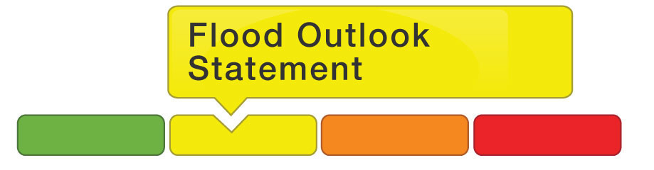
A Flood Outlook Statement is early notice of the potential for flooding based on weather forecasts call for heavy rain, snowmelt high wind or other conditions that could lead to high runoff, cause ice jams, lakeshore flooding or erosion.
According to The National Hydrological Services Great Lakes Water Levels Information, water supplies to all the Great Lakes were above average in September and water levels of all the Great Lakes remain well above average. Lake Superior has the potential to reach or exceed record highs in October should wet conditions continue. Peak Lake Superior water levels with the forecasted wind may be expected to cause shoreline flooding hazards, localized flooding/erosion to occur in low-lying sections of waterfronts.
Shoreline flooding and/or erosion are possible in the coming weeks if substantial storm surge and wave action occurs. Strong shore-bound winds occurring from the north or west would pose the primary concern.
SSMRCA wishes to remind residents to exercise caution near lakefront areas during this time, as high water levels and/or wave action may pose significant erosion, flooding and public safety hazards.
Currently, Lake Superior water level is approximately 183.9 m IGLD85. The monthly mean water level of Lake Superior was 30 cm above its period-of-record (1918-2018) average, 18 cm higher than last year’s level and just 2 cm below the record high set in 1950. For additional reference, the SSMRCA shoreline flooding hazard level used for planning and development review is 184.2 m.
SSMRCA staff continue to monitor Lake Superior wind conditions and lake levels closely.
For further information contact:
Anjum Amin, P.Eng.
705-946-8530 ext.# 1003
|
Current Watershed Conditions
Sault Ste. Marie Region Conservation Authority (SSMRCA)

.jpg)